Discussions on the history and historiography of Australia's New England

Monday, June 16, 2025

Arabian Peninsula Wet Periods - a note

 My last note discussed Marine isotype Stages (MIS). These provided a dated measurement of glacial (dry climate) and interglacial (wetter) periods over extended time periods. The most relevant time periods from our perspective are summarised below 

"MIS 4 – 71

MIS 5 – 130, usually sub-divided into a to e:

MIS 5a – 82 (peak of interglacial sub-stage)

MIS 5b – 87 (peak of glacial sub-stage)

MIS 5c – 96 (peak of interglacial sub-stage)

MIS 5d – 109 (peak of glacial sub-stage)

MIS 5e – 123 (peak of Last Interglacial, also known as the Eemian among other names)

MIS 6 – 191 (Penultimate Glacial Period, also called Illinoian glacial in North America, later Saalian in northern Europe and later Wolstonian in Britain)

MIS 7 – 243 (Aveley Interglacial in Britain)"

If the Aboriginal ancestors came out of Africa they would have had to travel through the Arabian Peninsula. But was that possible? The work of Abi Stone et al (2023) suggest that it was.

Abstract:

"Past environmental and climatic conditions within the Arabian Peninsula are key to understanding the setting for hominin dispersal across the Saharo-Arabian dryland belt. The tufa deposits within the volcanic harrats on the southwest coast of Saudi Arabia fill a significant spatial gap in the distribution of palaeoenvironmental records on the west coast of the Arabian Peninsula adjacent to the Red Sea. In the catchment of Wadi Dabsa in the Harrat Al Birk, there are widespread fossil palustrine to shallow-lacustrine tufa deposits with fluvial elements. Several phases of tufa accumulation, separated by fluvial downcutting, are observable within these powerful palaeoenvironmental proxies. U–Th dating of targeted dense, banded tufa facies, yield ages that are stratigraphically consistent at the landscape scale, and indicate that tufa accumulation occurred during distinct humid phases broadly coeval with the last two warm interglacial Marine Isotope Stages (MIS 7 and MIS 5). For the first time this shows humid intervals in southwest Arabia coincident with the southern coast. There is a similar pattern emerging further north in the Arabian Peninsula, The Sinai and Levant and further on into continental Europe. Furthermore, tufa δ18O ranges from −14.6 to −1.9‰, covering a range similar to those reported for tufa from north African oasis sites and speleothems elsewhere on the Arabian Peninsula and The Levant. The lowest δ18O values are derived from MIS 5e samples, a pattern in agreement with speleothems in Yemen and Oman, and consistent with an isotopic-enabled climate model simulation for this time slice. The δ13C and Sr isotopic compositions of dated tufa samples indicate deposition from shallow-circulating meteoric water, with no geothermal influence. This, along with the δ18O values, suggest a freshwater supply that was a potable water source in this landscape. The δ13C signatures at Wadi Dabsa are more negative than for parts of north Africa, suggesting Wadi Dabsa may have experienced comparatively higher biomass, thicker soils and wetter conditions with lower evaporative losses. This new record of tufa deposition during the middle and late Pleistocene, suggests for the first time that the west coast of Arabia experienced a similar history of humid phases over the past 250 ka as southern Arabia and the Nefud in the northern interior. These regional changes in hydroclimatic regime occur at timescales coincident with hominin dispersals." Abi Stone, Robyn H. Inglis, Ian Candy, Diana Sahy, Anne-Lise Jourdan, Dan N. Barfod, Abdullah M. Alsharekh, “Humid phases on the southwestern Arabian Peninsula are consistent with the last two interglacials”, Quaternary Science Reviews, Volume 319, 2023, https://doi.org/10.1016/j.quascirev.2023.108333 

Comment

The warmer wet periods suggested by the analysis do appear to fit with an out of Africa date of 72000 kya (MIS 5). An earlier date might also be possible to fit with MIS 7 should the present latest date for occupation within Sahul (c65,000 kya) be pushed back. 


Thursday, June 12, 2025

Marine Isotype Stages - a note

 DNA analysis suggests that the descendants of Australia's Aboriginal peoples left Africa perhaps 72,000 years ago. To reach Australia they would have travelled through the Arabian Peninsula. This is a desert area today, difficult to traverse. But was this always so? Were there periods when  the Peninsula was green in whole or part, when the Aboriginal ancestors might have passed? 

A clue here might be provided by Marine isotype stages (MIS). The material that follows is drawn from Wikipedia. 

What are Marine isotype stages?

Quoting:

"Marine isotope stages (MIS), marine oxygen-isotope stages, or oxygen isotope stages (OIS), are alternating warm and cool periods in the Earth's paleoclimate, deduced from oxygen isotope data derived from deep sea core samples. Working backwards from the present, which is MIS 1 in the scale, stages with even numbers have high levels of oxygen-18 and represent cold glacial periods, while the odd-numbered stages are lows in the oxygen-18 figures, representing warm interglacial intervals. The data are derived from pollen and foraminifera (plankton) remains in drilled marine sediment cores, sapropels, and other data that reflect historic climate; these are called proxies."

 The Stages


The following represents the dates etc of some of the stages most relevant to my topic.

Quoting

"The following are the start dates (apart from MIS 5 sub-stages) of the most recent MIS (Lisiecki & Raymo 2005, LR04 Benthic Stack). The figures, in thousands of years ago, are from Lisiecki's website.[13] Numbers for substages in MIS 5 denote peaks of substages rather than boundaries.

MIS     Start date
MIS 1 – 14 kya, end of the Younger Dryas marks the start of the Holocene. The LR04 date of 14 kya had to accommodate less well studied time intervals, and the generally accepted date of 11.7 kya is to be preferred.[14]
MIS 2 – 29 (Last Glacial Maximum)
MIS 3 – 57[a] (MIS 2-4 is called the Last Glacial Period, Wisconsinan glaciation in North America, Weichselian glaciation in northern Europe)
MIS 4 – 71
MIS 5 – 130, usually sub-divided into a to e:
MIS 5a – 82 (peak of interglacial sub-stage)
MIS 5b – 87 (peak of glacial sub-stage)
MIS 5c – 96 (peak of interglacial sub-stage)
MIS 5d – 109 (peak of glacial sub-stage)
MIS 5e – 123 (peak of Last Interglacial, also known as the Eemian among other names)
MIS 6 – 191 (Penultimate Glacial Period, also called Illinoian glacial in North America, later Saalian in northern Europe and later Wolstonian in Britain)
MIS 7 – 243 (Aveley Interglacial in Britain)
MIS 8 – 300 (early Wolstonian in Britain)
MIS 9 – 337 (Purfleet Interglacial in Britain)[16]
MIS 10 – 374
MIS 11 – 424 (Hoxnian Interglacial in Britain, and Holstein Interglacial in Central Europe)"

Comment

If you look at the stages you will see that MIS 4 and 5 are the most relevant to our story. In my next note I will move from the broad stages to look at some of the research relating to the Arabian peninsula to check when the Aboriginal ancestors might have been able to come. 

Saturday, May 31, 2025

Immediate priorities in the writing of New England's history - Aboriginal New England to 1788: Origins

 My present first priority in completing my history of Australia's New England is the creation of a full working draft for the history of New England's Aboriginal peoples to 1788 starting with origins and journey.  Where and when did their ancestors come from? How did they get to Sahul? Who did they mix with on the way? When did they arrive in the area that I call New England? How did they get there?

I covered this material in my lecture series to Armidale U3A but now need to consolidate and update it. Power points are a real trap here. A set of summary power points does not a history make! I had become very dissatisfied with my work but then realised that was silly. I am presenting a story, really a series of hypotheses linked to create a synthesis. No matter how much time I spend there will always be errors of fact and interpretation. Better to get it out there so that it can be critiqued, recognising that the pace of new discoveries will quickly over-run my analysis.  


Friday, May 30, 2025

Belated Blogging update 30 May 2025

 While personal circumstances have limited all my research and writing activities, I have kept this blog open to allow for comments on past posts since it is clear that people are still reading it and commenting. Since my last post on 7 November 2023 there have been dozens of such comments excluding the inevitable spam, many on posts from early in the blog's history. Together, they constitute quite a valuable resource. 

 Some months ago I returned to research and writing (and book buying!) focused on my main history projects. This was mildly depressing at two levels: I found more gaps in my research, while there had been a mass of new material published that I needed to take into account! Still, I am now at the stage where I feel the need to revive this blog. Hopefully I can do this in a productive way.   

Tuesday, November 07, 2023

Introducing the Museum of Stone Tools - an invaluable resource


One of the challenges in teaching the history of Australia's New England over such a long period lies in the sheer range of topics and disciplines that need to be included. One example is the stone artifacts that formed key elements in Aboriginal toolkits. 

Uniface pebble chopper tools from the Seeland's dig, Clarence Valley

From these surviving physical manifestations we can deduce something about the changing patterns of life over time, about the relationship between the Aborigines and their environments, about trade and the relationships between Aboriginal groups.

I started with some base knowledge in this area. Back in the 1960s I was a student member of Isabel McBryde’s pioneering UNE prehistory group. My second paying job during University vacations was as a research assistant for Isabel sorting, classifying and recording stone tools. However, in 2020 when I came integrate Aboriginal tools into my story of Aboriginal New England to 1788, part of my broader course on New England’s history to 1788, the gaps in my knowledge quickly became clear. 


The 2020 course was badly affected by the covid epidemic. However, one plus of the epidemic and its shutdowns is that it led UNE’s Professor Mark Moore to begin the development of the on-line Museum of Stone Tools. Mark is one of Australia’s leading archaeologists and an expert in stone flaking techniques. 

Professor Mark Moore

The resulting museum provides examples of various stone tools from across the world supported by explanatory material. Central to it are 3D models that allow you to play with various implements rotating them as required. The overall analysis is simple and accessible designed for people of all ages. You do not need specialist knowledge to understand. 

I hope to run my course again in the second half of next year. I think that the museum will prove a real blessing. In the meantime, do have a browse.


Monday, October 10, 2022

The impact of periodic drought on Aboriginal life and history - a note

Interesting piece in The Conversation (6 October) by Kathryn Allen, Alison O'Donnell, Benjamin I. Cook, Jonathan Palmer and Pauline Grierson, "Megadroughts helped topple ancient empires. We’ve found their traces in Australia’s past, and expect more to come".  The article includes a link to a 2016 paper that I had not seen that attempts to construct  a 1013 year rainfall chart for the Williams River in the Hunter Valley - Carly R. Tozer, Tessa R. Vance, Jason L. Roberts, Anthony S. Kiem, Mark A. J. Curran and Andrew D. Moy, "An ice core derived 1013-year catchment-scale annual rainfall reconstruction in subtropical eastern Australia", Hydrol. Earth Syst. Sci., 20, 1703–1717, 2016, www.hydrol-earth-syst-sci.net/20/1703/2016/ doi:10.5194/hess-20-1703-2016.

Attempts to reconstruct Aboriginal history over the long period of human occupation of Sahul then the later Australian continent including my own for the broader New England tend to focus on broader trends such as the impact of the Last Glacial Maximum and the subsequent emergence of the Holocene. While this is inevitable,  it is easy to ignore the significant impact on Aboriginal life of major changes within periods including long mega droughts and subsequent wet periods. 

If we take the Murray River as an example, I'm working from memory here, Mulvaney notes the evidence of periodic malnutrition in skeletal remains. Here we have relatively small territories with substantial populations dependent upon drought exposed riverine resources. On New England's western slopes and plains the pattern of life seems clearly affected by periodic droughts. 

I haven't worked all this through. For the moment, this is just a note for further thought.  

Tuesday, October 04, 2022

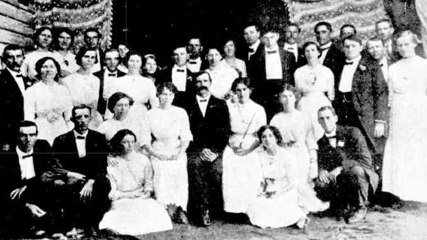
Taree's first eisteddfod, 1913

The Kurri Kurri choir who won the chief choral contest at the 1913 Taree eisteddfod (Photo  MidCoast Stories via the ABC)
Interesting piece by the ABC's Emma Siossian, Taree's first eisteddfod in 1913 was an impressive feat of logistics and planning.

As Heritage website  MidCoast Stories co-founder Penny Teerman noted, music festivals were popular in the early 20th century. In 1912, a limited but successful festival was held in Taree. This provided the impetus the following year for the formation of the Manning River Musical Festival Society - Penny calls it the Taree Musical Society but Trove searches suggest that it had a broader title  - to put on a larger event with multiple activities. This was a considerable success with multiple performers and a large number of spectators. 

The Leichhardt Boy's Choir performed in Taree during 1913..(Photo  MidCoast Stories via ABC)

I will leave you to read the story but wanted to make a few comments from my perspective as an historian of the broader New England. 

I was not sure about the use of the word eisteddfod. I think that the first named eisteddfod was put on in Ballarat in 1855 by Welsh miners attracted to the new gold fields, but widespread use of the name as opposed to musical festivals came later. I checked Trove, and the name eisteddfod was indeed used

Transport difficulties limited the scope of major events. On the North Coast where river transport was possible, events would draw along river routes. As the railways spread, they provided a means of drawing in a broader audience or group of participants. The 1913 Taree eisteddfod followed the opening of the railway. Participation still focused on surrounding areas but broader participation was possible, We can see this in 1913: participants came from regional areas linked by the railway but participation from the more distant Leichardt Boys Choir was also possible if more expensive

I noted the Kurri Kurri Choir. Music was an important form of shared entertainment on the coal fields. The number of attendees at band performances is a sign of just how popular local band music was.  

Tuesday, August 30, 2022

New DNA studies provide new light on the mixing of people in the classical world

 Interesting piece by Andrew Curry in Science, "‘Phenomenal’ ancient DNA data set provides clues to origin of farming and early languages: Trio of studies suggests new homeland for earliest Indo-European speakers and traces movements of ancient Greeks, Imperial Romans". The story includes links to related stories. 

I'm not quite sure how to interpret the material, but it does show (again!) how genomics is throwing new light on evidence revealed via the archaeological record.  

Friday, January 21, 2022

Callum Clayton-Dixon’s Surviving New England

As my first post for the new year, I am publishing the book review originally published in the Armidale and District Historical Society Journal in October last year. I am publishing it here because the Journal is not on-line. Callum's book deals with the frontier warfare period on the New England Tablelands. 

I think that's it's an important book written from an Aboriginal perspective focused on the Aborigines as people with agency. These stories need to be told at regional level. If we examine Callum's work with other studies such as Mark Dunn's Convict Valley we have a much better chance of building a coherent story that includes inter-regional interactions. I wish someone would do a similar study of the North Coast.   

Book Review: Callum Clayton-Dixon’s Surviving New England

Callum Clayton-Dixon’s Surviving New England: A history of Aboriginal resistance and resilience through the first forty years of the colonial apocalypse[i] is an important book, although some find it discomforting.

Clearly and simply written, the book discuses  the impact of European occupation on the life of the Aboriginal peoples living on Australia’s New England Tablelands from the 1830s into the 1860s. In doing so, it focuses on the Aboriginal experience in a particular area at a critical point in time.

Background: the importance of regional studies

We sometimes talk of the “Australian Aborigines” as though they were and are a single entity. We know that this is not true, but the habit lingers, affecting the way we approach both policy development and historical analysis.

We now know that the Aboriginal and Papuan ancestors arrived on the mega-continent we now call Sahul perhaps 65,000 years ago. This was the Pleistocene, a geological epoch marked by recurrent ice ages during which sea levels fell and rose as the ice advanced and retreated. With lower sea levels, Papua-New Guinea, the current Australian continent, Tasmania and much of the continental shelf were joined in a single great continent. 

By 42,000 to 40,000 years ago, all of Sahul from the Papuan Islands in the north to Tasmania in the south had been at least lightly occupied. Around 21,000 years ago a cold and desolate period known as the Last Glacial Maximum began. Sea levels fell to perhaps 130 metres below present levels, temperatures fell dramatically on land and in the sea, rainfalls declined sharply.  This forced the Aboriginal ancestors to retreat and regroup and may have threatened the very existence of human occupation of Sahul.

Around 15,000 years ago a warmer period known as the Holocene began, As the glaciers melted, the seas rushed back separating Papua and Tasmania from the Sahul mainland, submerging large areas of the continental shelf. This period is recorded in Aboriginal folk lore referencing great floods.

By 1788, a complex Aboriginal society had emerged across the new Australian continent. This society was not uniform, but varied from area to area in culture and relationships with the landscape. This society would now be torn apart, a process that varied across space and time depending on the spread of European settlement, local conditions and the policies of the emerging colonial jurisdictions.

I make these points because a proper understanding of our history and especially Aboriginal history requires a focus on local and regional experiences.

As I read Callum’s book, I thought just how well it fitted into the New England historiography tradition. 

Both the Armidale Teachers’ College (later the Armidale College of Advanced Education) and the New England University College (now the University of New England, UNE) were founded in part to study and preserve the history and culture of Northern NSW, the North.

When Isabel McBryde came to Armidale in 1960, she was the first tenured Australian university staff member to have the word prehistory in her title. The students she recruited to study the ethnography and prehistory of the broader New England would form the first archaeology and prehistory honours class in Australia,

From the beginning and under the influence of her mentor John Mulvaney, Isabel focused on the creation of a regional historical sequence. She and John believed that the variety in Aboriginal culture and society meant that you could not understand the history without a focus on regional studies. In parallel, the English Department’s Bill Hoddinott began the documentation of Aboriginal languages within Northern NSW.

In 1962, Robin Walker published an article discussing the relations between Aborigines and settlers in New England 1818-1910.[ii]  

In 1966, two years before W E H Stanner coined the phrase the Great Australian Silence to describe the absence of Aboriginal history in Australian history, Walker published Old New England, a history of the Northern Tablelands from 1818 to 1900.[iii] While Walker focused on the settler experience, the book begins with an outline of Aboriginal life prior to European occupation. Later, it explicitly recognises the existence of frontier warfare including massacres and retaliatory killings and the damage done to Aboriginal society as a consequence of disease and disruption.

In 1981, Geoff Blomfield published the first edition of Baal Belbora: The End of the Dancing[iv], a study of warfare, massacres and frontier violence in the Falls’ country of Southern New England.

Callum’s Perspective

These few examples suggest the importance of regional studies, as well as showing early recognition of both frontier warfare and the impact of European occupation on Aboriginal society. However, they were all written by non-Aboriginal people.

Callum writes from an Aboriginal perspective. His focus is more personal, more political. It centres on the Aborigines as people with agency, people who responded to invasion by fighting back against overwhelming odds.

This is a very different perspective from the sometimes simple minded focus on the Aborigines as victims. To Callum, his ancestors were warriors who in the end survived. In writing, he seeks to instil pride in an often oppressed group.  

 Callum’s position is clearly set out the book’s Introduction. It begins with his discovery of his Aboriginal ancestry, of his return to the country of his ancestors, of his attempt to discover and reconnect with country.

Callum writes from a particular post-colonial mental structure. As Callum discovered his own past, he became involved with groups such as the Warriors of the Aboriginal Resistance who were determined to tear down the mental, social and legal barriers that prevented proper recognition and reconstruction, the reinstatement of the rights of all the Aboriginal peoples.

Callum’s position is not limited to Australia’s Aboriginal peoples, but indigenous peoples everywhere. To his mind, justice demands the deconstruction of structures created by colonialism and their replacement by new structures that properly recognise indigenous ownership and rights.

This approach could leave him open to the charge that his book is a polemic, a political statement, rather than a piece of historical research. That would be unjust. This is good history. I say this for several reasons.

All historians write from particular perspectives. This affects the questions they ask and evidence selected. Often, these positions have to be inferred. By contrast, Callum tells us where he is coming from. We can therefore make our own judgements on approach and evidence presented. Here Callum has been careful to document his evidence, allowing us to follow up, to check his sources and again form our own views.

A mark of good history is the extent to which it provides insights that allow us to see patterns, to develop new ideas. Callum’s book passes this test.

Setting the Scene

Having outlined his personal position, Callum discusses key questions that set a framework for the following story of resistance. What was the Aboriginal population of the Tablelands at the time of British occupation? How rapidly did occupation proceed? What was the impact of British occupation on the Aboriginal peoples and population?

 When I made the first estimates of the distribution of Aboriginal populations across Northern NSW, I worked (as Callum does) from settler and official records.[v] In doing so, I was unaware of the impact of diseases such as smallpox, influenza, measles and venereal infections that spread far beyond the moving frontier. This affected population size directly through deaths and then through reduced fertility rates within surviving populations.

Taking this into account, Callum estimates the Tablelands’ population as between 1,100 and 1,200 people. Accepting that the Tablelands were not as productive in Aboriginal terms as the coast and western slopes and immediate plains, I suspect that this is an underestimate. I say this because the number of recorded languages and their supporting dialects, the number of recorded Aboriginal groups, is quite high. A simple division of these numbers into the population estimates gives figures too small to be viable units in demographic terms.

Perhaps wisely given the population uncertainties, Callum does not attempt to scope the number of warriors (men of fighting age) at the time of European occupation. This is an important issue because it helps scope the scale of the conflict that followed. If we exclude women, children and older men, a population of 1,200 suggests perhaps 400 warriors spread across multiple local groups.

Using graphs, Callum charts the rapid growth of the settler population across the New England Tablelands from 1830 to 1850. European occupation began in the early 1830s with the squatters coming in two streams, one inland from the Hunter, the second from Port Macquarie where Archibald Clunes Innes had established his headquarters.

This expansion was driven by demand for the wool required to feed the growing British textile industry. It was also driven by a speculative fever as the new settlers sought to build their fortunes.

The New England Tablelands may have been a relatively poor territory in Aboriginal terms, but it was well suited to wool growing. The result was a settlement explosion.  By the time Crown Lands Commissioner Macdonald established his headquarters in 1839 at the place now called Armidale, much of the New England was at least lightly occupied. By 1841, the European population had reached 1,115, rising to 2,231 in 1846. The Aborigines were now in a minority. The effect is more pronounced still if we consider the male population, for in this period there were few women in the European population. This meant that the number of European men of what we might call military age outnumbered the number of Aboriginal warriors well before the European population outnumbered the Aboriginal population. 

Patterns of Aboriginal Resistance

European expansion had devastating effects on Aboriginal traditional life. Beyond the effects of disease, beyond losses in frontier warfare, came the effects associated with destruction of habitat as the Aboriginal peoples were denied access to the traditional lands, forced to retreat to marginal areas. Callum calls this process ecocide, the sometimes deliberate destruction of the economy and environment on which a people depends for their survival.

Callum explores the Aboriginal response in a number of chapters plus an appendix that lists all the examples of frontier violence that he has found from the records as well as Aboriginal memories, some 41 items in all. Unlike the University of Newcastle’s Colonial massacres project which focuses on specifically defined massacres[vi], Callum’s focus on the Aboriginal response means that he is as interested in all types of Aboriginal response against the European invasion.

I think that this is very important in opening new areas of historical analysis, although I think that there are weaknesses in Callum’s analysis, areas that he does not address.

This may sound like a criticism. It is not. Callum has proven his basic point, that the Aboriginal peoples were people with agency who fought back. He has opened new ground for historical research, new questions and structures that I find interesting. He and we can build on his research to tell new stories.

To extend my argument, using Callum’s structure we can think of the Aboriginal response in terms of three phases, sometimes uneasy co-existence, resistance and then survival. We can also think of this in terms of the structure of Aboriginal society, the structure of European colonial society and the way the two played out in the pattern of frontier life. We can also think of this in regional and local terms. Here we can learn much from other regional studies such as Mark Dunn’s The Convict Valley, the story of early European settlement on the Hunter[vii].These regional studies allow us to learn much about different patterns over space and time, but also allow us to see interconnections between different areas.

If you look at the patterns of early Aboriginal resistance, they included attacks on isolated individuals with attacks on stock. The Aborigines were selective in such attacks, focusing on individuals who had done them wrong. As resistance gathered strength, you had large scale attacks on people and stock.

In both the Hunter and on the New England, the European response forced Aboriginal groups to the more remote and rugged country where horses could not easily penetrate. There different Aboriginal groups came together to mount larger scale attacks on people and stock. On the New England, for example, growing European settlement on the coast seems to have forced coastal Aborigines to the west where they joined with Tablelands’ groups including traditional enemies to mount large scale attacks. The patterns created last to this day.

The exact patterns including regional linkages are poorly understood. As Callum notes, he had to develop his synthesis from a variety of often fragmented early settler and official records, records written from the other side of the conflict.

Reading Callum’s work in conjunction with other studies such as Mark’s. I thought that there that there is so much more that we might say. We will never know of course, we have to infer so much, but Callum’s work gives us another block to build from.

Publication Details:

Jim Belshaw, “Book Review: Surviving New England”, Armidale and District Historical Society Journal and Proceedings, No 64, October 2021, pp 102-106


[i]  Callum Clayton-Dixson, Surviving New England, Aniawan Language Revival Program, Armidale 2019. Reprinted NEWARA Aboriginal Corporation, Armidale 2020

[ii] R B Walker,  ‘The Relations between Aborigines and Settlers in New England 1818-1900, Armidale and District Historical Society Journal, 4, 1962 pp1-18

[iii] R B Walker,  Old New England: A history of the Northern Tablelands of New South Wales 1818-1900, Sydney University Press, 1966

[iv] Geoff Blomfield,  Baal Belbora: The End of the Dancing, Apcol, 1981

[v] Jim Belshaw, The Economic Basis of Aboriginal Life in Northern New South Wales in the Nineteenth Century, BA Hons thesis, University of New England, 1966; J Belshaw, ‘Population distribution and the pattern of seasonal movement in northern New South Wales’, in Records of Times Past, I McBryde (ed.). Australian Institute of Aboriginal Studies, Canberra: 1978, pp.65-81

[vi] Colonial Frontier Massacres in Australia, 1788-1930, University of Newcastle, https://c21ch.newcastle.edu.au/colonialmassacres/

[vii] Mark Dunn The Convict Valley The bloody struggle on Australia's early frontier Allen & Unwin June 2020


Saturday, December 04, 2021

The fall of Archibald Clunes Innes

In 1840, Port Macquarie’s Archibald Clunes Innes was at the height of his wealth and power with stores, pastoral runs and real estate holdings on the coast and across the New England. Now he faced economic storms of cyclonic proportions.   

Opposition to transportation had been rising, driven in part by the growing number of free workers especially in Sydney who saw the convicts as an economic threat, in part by those who believed that continued transportation was incompatible with the development of a free colony.


Aberglasslyn House outside Maitland is an example of the rise and falls associated with the crash of the early 1840s. This monumental Georgian pile designed by architect John Verge for George Hobler, remained unfinished following Hoblers insolvency in the crash.

In face of protests, transportation to NSW was suspended in 1840. Innes had built his wealth in part on access to convict labour to service his growing empire. Now he and other squatters faced labour shortages together with rising wage costs, leading to a search for new workers.

 Later in the decade, this would bring the first Chinese and German workers to New England, but the initial effects were severe. However, these were the least of Innes’s problems.

Over the 1820s and 1830s NSW experienced a sustained economic boom.

High wool prices fueled pastoral expansion which in turn inflated stock prices. The previously small European population grew from 7,040 in 1807 to 28,024 in 1820, to over 44,000 in 1830, passing 127,000 in 1847, inflating real estate prices. Land sales inflated Government revenues that were used in part to fund immigration.

 Growth required capital drawn heavily from English investors and the London capital market, fueling the growing boom. Fortunes were being made from speculation in stock and real estate, fortunes invested in further speculation and in the construction of the first grand homes including Lake Innes House. Now all this came to a shuddering halt.  

 In 1837, a speculation fueled US boom part fueled by English capital crashed. This led to a financial crisis in England in 1839, drying up the capital that had been fueling the NSW boom.

Wool prices dropped sharply as did live stock prices, a fall accentuated by the ending of the rapid pastoral expansion that had driven up prices as stock was purchased to stock the new runs. Government revenues from land sales fell sharply, creating a Government financial crisis.

The end result was a rolling series of bankruptcies among those who most exposed to the boom including that of merchant, pastoralist and steamship owner Joseph Grose in 1844. Grose’s spread of interests made him a considerable figure in the early colonial history of Northern NSW’

 Innes could not escape the turmoil. Initially he seems to have refinanced his operations using family money. But then, in 1843, the collapse of a large Sydney based pastoral house led to the collapse of a major local bank that would finally force Innes into bankruptcy. An era had ended.

Saturday, November 20, 2021

Archibald Clunes Innes, a major figure in New England's early colonial history, reflects the the rise and fall of Port Macquarie


Lake Innes House, Port Macquarie, 1839, where Archibald Clunes Innes entertained in lavish style.

The rise and subsequent decline of Port Macquarie from the centre of British civilization in the North to quiet backwater is captured in the rise and fall of one man, Archibald Clunes Innes. His story tells us much about New England’s early colonial history.  

Innes (1800-1857)  was born at Thrumster, Scotland, the son of Major James Innes, a distinguished soldier. At thirteen, he joined the army as an ensign, serving in the Peninsular War against Napoleon. 

Innes arrived in Sydney in 1822 as captain of the guard in the convict ship Eliza. There he quickly moved up the colonial hierarchy, including six months as commandant of the Port Macquarie penal colony. 

In 1829 at one of the most magnificent weddings that the colony had then seen, Innes married Margaret, daughter of the colonial secretary, Alexander McLeay. 

McLeay, the builder of Sydney icon Elizabeth Bay House, was one of Sydney’s wealthiest and most prominent men. The Macleay River carries his name. 

Having resigned his commission in 1829, Innes became police magistrate at Port Macquarie in 1830 and was granted 2568 acres (1039 ha) of land and contracts to supply the convict population with food.

By 1840, Innes was one of the wealthiest men in the colony. 

Working from his initial base, he had acquired sheep and cattle stations all over Northern New South Wales, among them Yarrows on the Hastings, Brimbine and Innestown on the Manning, Waterloo, Innes Creek, Kentucky and Beardy Plains on the Tablelands. His acquisition of Furracabad and the creation of the store on that station would provide the base for the development of Glen Innes. 

To support his growing empire he created stores, would build the first convict built road onto the Tablelands and began exporting wool from Port Macquarie to Sydney. In his mind, I think, he saw Port Macquarie developing as a major commercial centre and port servicing the New England. 

As a sign of his growing wealth, Innes used convict labour to build Lake Innes House, a grand new home suitable to his aspirations. There he entertained lavishly supported by staff including a butler, musicians, maids and stable hands. The staff included New England’s first Spanish settlers. 

As Innes’s interests developed, Port Macquarie became an immigration centre bringing in new and especially Scottish settlers who would move onto the Tablelands. Among those who came were his cousin William Tydd Taylor and wife Margaretta Lucy Lind who would take up what became known as Terrible Vale Station.  

Archibald Clunes Innes was now at the peak of wealth and power, but disaster lay ahead. 

Note to readers: This post was prepared as a column for the on-line edition of the Armidale Express. I am repeating the columns here with a lag because they are not all on line outside subscription. You can see all the Belshaw World and History Revisited/History Matters columns by clicking here for 2009, here for 2010, here for 2011, here for 2012, here for 2013, here for 2014, here for 2015,  here for 2016, here  2017here 2018, here 2019, here 2020, here 2021 


Saturday, November 06, 2021

Port Macquarie: the centre of British civilization in the north


Port Macquarie, 1832, by convict artist Joseph Backler.

I wonder how many New Englanders know that for more than a decade Port Macquarie was the centre of British civilization on Northern NSW? 

Maitland (1829) together with its adjoining river port at Morpeth (1831) would develop into the largest urban conglomeration in the North, but this still lay ahead. 

The penal colony at Newcastle had been established in 1804 as a place of secondary punishment for re-offending convicts, but problems soon emerged. 

Newcastle was just too close to the Sydney fleshspots, to accessible by land, providing the incentive and means for absconding. There was also pressure to open up the Hunter for European settlement. 

There were initial land grants under Governor Macquarie, but these were limited to small grants to ex-convicts. However, further south the settlers on the Hawkesbury and in the Sydney Basin were seeking new pastures for their growing flocks and herds. As a consequence, the Hunter was opened up for European settlement in 1822. 

Explorer John Oxley had discovered and named Port Macquarie in 1818. This seemed a suitable site for a new penal colony to replace Newcastle, although Macquarie was initially uncertain. Finally, in 1821 the decision was made to proceed. 

In seeking to discover that far country called the past, we are all bound by current mind-sets in ways that we do not always understand. Port Macquarie is a case in point. 

I had always thought of Port Macquarie as a minor penal settlement founded from and close to Sydney, something equivalent to the establishment of the jail at Grafton many years later. The reality is different.

To begin with, the number or convicts sent to Port Macquarie was roughly similar in scale to those sent to Port Jackson in the early days. This was not a small settlement.

Like Port Jackson, convicts were expected to build the necessary infrastructure including barracks required to support the colony. Like Port Jackson, they were expected to grow their own food. And like Port Jackson, the Government was interested in exports from the new colony that might yield economic gain. 

The new colony was expected to be a punishment colony, a feared place of secondary punishment. But to accommodate the needs of the new colony, convicts volunteering to build Port Macquarie were offered special treatment.

Later, convicts sent to Port Macquarie were also granted special privileges in the treatment of things such as their own gardens. This, too, had happened at Port Jackson, but it created a fundamental problem. This can be put simply.

Port Macquarie was a place of secondary punishment, a place to be feared. How, then, do your reconcile the special treatment required to establish and then maintain the colony?

There were no easy answers to this question. It led to fluctuating treatment of the convicts as official balance switched between punishment and remediation. Meantime, a new town had emerged. 

Note to readers: This post was prepared as a column for the on-line edition of the Armidale Express. I am repeating the columns here with a lag because they are not all on line outside subscription. You can see all the Belshaw World and History Revisited/History Matters columns by clicking here for 2009, here for 2010, here for 2011, here for 2012, here for 2013, here for 2014, here for 2015,  here for 2016, here  2017here 2018, here 2019, here 2020, here 2021 

Saturday, October 30, 2021

New England History: Battle of Vinegar Hill led to northern settlement


One difficulty that I have faced as a regional historian specialising in the broader new state New England, the Tablelands and surrounding river valleys, is the absence of regional historical syntheses that allow us to fit our family, local and regional stories into a context. Everything is dominated by national or state stories or by very broad thematic studies that have only limited relevance to our own stories. 

 This absence has forced me to develop my own syntheses to provide a framework for my research. In past columns I have talked about Aboriginal New England to 1788. Over the next few columns I want to talk about our colonial history, starting with the penal period. Think of it as a primer into which you can fit your own research!

The first fleet arrived in 1788. In 1801, thirteen years later, a first attempt was made to establish a penal colony at the mouth of the Hunter. The attractions were the presence of coal, timber and the large shell middens that might provide lime for building. This first attempt failed.

 In 1804 a second successful attempt was made.

 On 4 March 1804, 233 Irish convicts launched a rebellion against British authority. The following day a force consisting of a mixture of military personnel and armed civilians defeated the rebels in a pitched battle at Castle Hill near Sydney.

This battle is sometimes called the second battle of Vinegar Hill named after an earlier uprising in Ireland for some of the prisoners who participated in the NSW uprising had been exiled as a consequence of their participation in the Irish uprising.

 Fifteen convicts were killed, nine were later executed, while 23 formed the core of a new penal colony established at Coal River, now Newcastle. There were no casualties on the British side.

 From the beginning, the new penal colony was seen as a place of secondary punishment that would also reduce the chances of the convicts escaping. This proved to be a forlorn hope. The fleshpots of Port Jackson were just too close.

 In the end, three penal colonies were established in Northern New South Wales each initially intended as a place of secondary punishment: 

  • Newcastle 1801, 1804-1823
  • Port Macquarie 1821-1830 
  •  Moreton Bay 1824 – 1842.

The reference to Moreton Bay may surprise, but Moreton Bay now Queensland was part of Northern NSW until Queensland gained self-government in 1859.

These three penal stations formed part of an integrated network of penal stations that would include Port Jackson, Van Diemen’s Land and Norfolk Island.

There was a constant flow of convicts between the different penal colonies, while each had to be serviced by shipping bringing in supplies while exporting local production. This laid the base for the coastal shipping network that form such an important part of New England’s history.

Of the three Northern penal colonies, Port Macquarie would have the greatest impact on New England’s history. I will turn to its story in my next column.

Note to readers: This post was prepared as a column for the on-line edition of the Armidale Express. I am repeating the columns here with a lag because they are not all on line outside subscription. You can see all the Belshaw World and History Revisited/History Matters columns by clicking here for 2009, here for 2010, here for 2011, here for 2012, here for 2013, here for 2014, here for 2015,  here for 2016, here  2017here 2018, here 2019, here 2020, here 2021 

Saturday, October 23, 2021

Indigenous Australians' right to vote and the 1967 constitutional referendum


Neville Bonner was the first Aboriginal member of the Australian Parliament, appointed to the Senate for the Liberal Party to fill a Queensland vacancy, in 1971.

There is a common view that Indigenous Australians’ right to vote is somehow connected with the 1967 constitutional referendum. That’s not correct. The story is far longer and more complex than that. 

In the 1850s under the constitutions of Victoria, New South Wales and South Australia, Aboriginal men had the same right to vote as other male British subjects aged over 21. 

In 1895 South Australia became the first jurisdiction in the world to give women the vote including Aboriginal women. Then in 1896 Tasmania granted Aboriginal men the franchise.

There were countervailing pressures to these advances. .

In 1885, a law was passed in Queensland to deny Aboriginal people the right to vote. Similar legislation was later enacted by Western Australia (1893) and the Northern Territory (1922). These were the jurisdictions where the frontier was most recent, the Aboriginal proportion of the population highest. 

With Federation, the 1902 Commonwealth Franchise Act granted men and women of all states the right to vote. Indigenous people were excluded from this right unless they already had the right to vote before 1901. This Act effectively institutionalised discrimination at national level so far as the franchise was concerned. 

As had happened during the First World War, a number of Aboriginal and Torres Strait Islanders served with the Australian military. In March 1949, the right to vote in federal elections was extended to any Indigenous person who had been a member of the defence forces. 

Within the states and territories, the “Dog Collar Acts” applying in some jurisdictions affected voting. These Acts exempted Indigenous people under strict conditions from the restrictions placed upon them. Effectively, Aboriginal people had to be granted “citizenship” to be able to vote. Again, the restrictions were greatest in WA, Queensland and Northern Territory.

Finally, in 1962 following report by a House of Representatives Select Committee, legislation was passed giving all Aboriginal people the right to enrol and vote in national elections.  Enrolment was not compulsory, but voting was if enrolled.

Following this, legislation, Western Australia and the Northern Territory granted Aboriginal people the right to vote. Then, in 1965, Queensland finally extended the right to vote to all Aboriginal and Torres Strait Islander people.

In 1984, voting at Federal level was made compulsory for all Indigenous Australians, removing the last difference.  

Note to readers: This post was prepared as a column for the on-line edition of the Armidale Express. I am repeating the columns here with a lag because they are not all on line outside subscription. You can see all the Belshaw World and History Revisited/History Matters columns by clicking here for 2009, here for 2010, here for 2011, here for 2012, here for 2013, here for 2014, here for 2015,  here for 2016, here  2017here 2018, here 2019, here 2020, here 2021 

Wednesday, September 01, 2021

Historical climate change on the Arabian peninsular, hominin occupation and the pattern of Aboriginal settlement of Sahul

The second lecture in my introductory course on the history of Australia's New England, the Tablelands and surrounding river valleys, traces the journey of the Aboriginal and Papuan ancestors from Africa until their arrival on the mega continent we now call Sahul. 

On 1 September 2021 an article by H S Groucutt et al was published in Nature that bears upon our story. The abstract including link to the paper follows. Comments follow the abstract.  

Pleistocene hominin dispersals out of, and back into, Africa necessarily involved traversing the diverse and often challenging environments of Southwest Asia. Archaeological and palaeontological records from the Levantine woodland zone document major biological and cultural shifts, such as alternating occupations by Homo sapiens and Neanderthals. However, Late Quaternary cultural, biological and environmental records from the vast arid zone that constitutes most of Southwest Asia remain scarce, limiting regional-scale insights into changes in hominin demography and behaviour. Here we report a series of dated palaeolake sequences, associated with stone tool assemblages and vertebrate fossils, from the Khall Amayshan 4 and Jubbah basins in the Nefud Desert. These findings, including the oldest dated hominin occupations in Arabia, reveal at least five hominin expansions into the Arabian interior, coinciding with brief ‘green’ windows of reduced aridity approximately 400, 300, 200, 130–75 and 55 thousand years ago. Each occupation phase is characterized by a distinct form of material culture, indicating colonization by diverse hominin groups, and a lack of long-term Southwest Asian population continuity. Within a general pattern of African and Eurasian hominin groups being separated by Pleistocene Saharo-Arabian aridity, our findings reveal the tempo and character of climatically modulated windows for dispersal and admixture.

Groucutt, H.S., White, T.S., Scerri, E.M.L. et al. Multiple hominin dispersals into Southwest Asia over the past 400,000 years. Nature (2021). https://doi.org/10.1038/s41586-021-03863-y

Comment

To the best of our present knowledge, the ancestors of the Aboriginal and Papuan peoples came out of Africa arriving in Sahul perhaps 65,000 years ago. This was during the Pleistocene, a period marked by ice ages separated by warmer periods. 

Today, Saudi Arabia is marked by arid deserts. This study suggests that the Arabian Peninsula experienced wetter green periods approximately 400, 300, 200, 130–75 and 55 thousand years ago. Each period was marked by different hominin occupations, with people withdrawing and reoccupying as the climate changed. 

From our viewpoint, the green period from 130-75,000 years ago would appear to fit with Aboriginal migration patterns given the present earliest indicated occupation date of c65,000 years ago.  

Postscript 

 An article in the Conversation  provides more commentary. Research reveals humans ventured out of Africa repeatedly as early as 400,000 years ago, to visit the rolling grasslands of Arabia  

Wednesday, April 07, 2021

Armidale's buildings mirror the city's history


Laying of the foundation stone for the Armidale Teachers' College Building.This is the fifth in a series exploring the rise, fall and slow recovery of the city of Armidale.  

The story of Armidale’s rise, fall and slow recovery is mirrored in the city’s built landscape. 

The city’s expansion over the last two decades of the nineteenth century is mirrored in the large generally brick homes and commercial buildings concentrated in the CBD and on South Hill. While little evidence remains of Armidale’s manufacturing base, the generally weatherboard workmen’s cottages built for industrial and railway workers remain, especially in West Armidale. 

By the mid twenties, the still small city was prosperous enough, although growth had stalled. Then in 1927 came the decision to establish the Armidale Teachers’ College. 

I explored the remarkable story of its establishment in an earlier series of columns. For the present, it brought staff and students to Armidale that compensated many times over for the 1926 shift of St John’s Theological College to Morpeth. 

Construction also began on one of Armidale’s most iconic buildings, the Parthenon on the Hill.  

In 1929 the Great Depression struck. Around Australia, a third of the workforce lost their jobs. 

Even as depression struck, construction of the new college building was pushed ahead, pumping money into the local economy. There were fears that the College might close, but the project was too far advanced. 

Staff and student numbers were cut, but then recovered as the depression began to ease. Armidale grew from 4,738 people in 1922 to 6,794 in 1933. 

In terms of the built landscape, the 1920s saw the emergence of the California bungalow that forms such an important part of the Armidale streetscape. Then, in the 1930s, came the art deco period seen in some Beardy Street buildings in particular as increased wealth translated into new or modified buildings. 

We now come to the most important development of all, the establishment of the New England University College (NEUC), opening in 1938. 

Like the Teachers’ College, the establishment of NEUC came about because of a combination of particular events external to Armidale. 

Yes, funding from particular New England families such as the Whites was critical. Yes, the local organising committee played a critical role. Yes, Armidale’s existing educational structure was important. 

But all these things would have failed had it not been for a basic fact: as with the Armidale Teachers’ College, the new university college was seen as a Northern endeavour, one that drew support from across Northern NSW. 

In my next column I will carry the story through into Armidale’s rapid growth period. 

Note to readers: This post was prepared as a column for the on-line edition of the Armidale Express. I am repeating the columns here with a lag because they are not all on line outside subscription. You can see all the Belshaw World and History Revisited/History Matters columns by clicking here for 2009, here for 2010, here for 2011, here for 2012, here for 2013, here for 2014, here for 2015,  here for 2016, here  2017here 2018, here 2019, here 2020, here 2021