Discussions on the history and historiography of Australia's New England

Sunday, November 29, 2009

Don Aitkin's What was it all for?

This is one of a number of a number of parallel posts recording my reactions to Don Aitkin's What was it all for? The Reshaping of Australia. (Allen & Unwin, Crows Nest, 2005). I will add a full list of posts later.

Because the book centres on social change in Australia over fifty or so years as seen in part through the eyes of the Armidale High School leaving certificate class of 1953, it is very relevant to the history of New England.

I had intended to finish my current history of New England in 1967, the year of the loss of the the New State plebiscite, with just an overview pointing to the future. I chose this date in part because it represented a key loss, in part because the later period enters what we can think of as current affairs rather than history.

Reading Don, I think that I need to carry the story through at least in sketch form to the end of the twentieth century.

This really is a good book.      
Saturday, November 28, 2009

What was the best New England history published in 2009?

In The History Crop of 2009: not one of the great vintages?, Christopher Moore pondered on the apparent absence of good Canadian history published in 2009. The post includes a comparative link to a review of the best history published in the UK.

This got me wondering.

What was the best New England history published in 2009? Was there in fact anything published? Accepting the very small number of readers on this blog, I thought that the question was worth asking.   

Sunday, November 15, 2009

New England's History - most popular posts 3

It is just over one year since I last posted on the most popular posts on this blog. Time to resume.

By far the most popular post, as it was in July and November 2008, was Geography of New England - Introduction. I suspect that part of the reason for this is that those interested in the US's New England are also attracted.

I put this post up on November 2006, so it's quite old. Given it's continuing popularity, I need to add to it links to later writing to give the visitor a better guide.

The next most popular was the archive for March 2008. I have no idea which of the small number of posts in that month attracted interest.

Then came three equal posts.

The first was a search term that I did not understand, http://newenglandhistory.blogspot.com/?expref=next-blog, that brought up a number of posts.  The second was the Anaiwan or Nganyaywana entry page, another post that requires up-dating to bring in later work. The third post was Hunter Valley Aboriginal Groups. This post, too, requires an update.

After a short gap came another geography post, Geography of New England - Impact of Great Dividing Range, a post that was in the top three in my last update.

This was followed by two further posts, How fast do horses travel? and then New England Australia - Karuah River and Great Lakes catchment map. How fast do horses travel? has featured in the top posts in all three updates, so there is again a consistent pattern.

Given the continuing interest I have decided to start my updates with the introductory geography post to give visitors a little greater value for their time.

Friday, November 13, 2009

Newcastle's Niagara Cafe and the Karanges family

I have been reading William R Claridge's The Pommy Town Years: Memories of Mayfield and Other Tales of the Twenties (William Michael Press in conjunction with the University of Newcastle, Newcastle, 2000).

In that book I found a little of the story of Angelo Burgess (Bourtzos), the Niagara Cafe and the Karanges family.

I want to write something on this. This post simply notes the fact and preserves a link to a fuller story of the Karanges.

Saturday, November 07, 2009

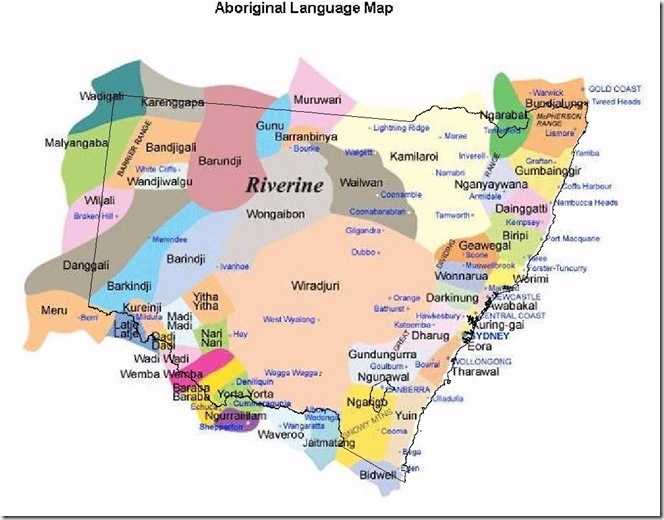
Impact of State Boundaries on Aboriginal Language Groups

A little while ago I put up a map showing the distribution of Aboriginal languages across NSW. A colleague, John Baker, kindly superimposed the NSW state boundaries on the map. The slight skew is due to the structure of the original map.

The reason I am posting it is that the map shows quite clearly the way in which state boundaries cut across different groups. This had significant effects on those involved because of differences in state and territory policies towards the Aborigines.     

for Jim (2)