Discussions on the history and historiography of Australia's New England

Showing posts with label environment. Show all posts

Monday, October 10, 2022

The impact of periodic drought on Aboriginal life and history - a note

Interesting piece in The Conversation (6 October) by Kathryn Allen, Alison O'Donnell, Benjamin I. Cook, Jonathan Palmer and Pauline Grierson, "Megadroughts helped topple ancient empires. We’ve found their traces in Australia’s past, and expect more to come".  The article includes a link to a 2016 paper that I had not seen that attempts to construct  a 1013 year rainfall chart for the Williams River in the Hunter Valley - Carly R. Tozer, Tessa R. Vance, Jason L. Roberts, Anthony S. Kiem, Mark A. J. Curran and Andrew D. Moy, "An ice core derived 1013-year catchment-scale annual rainfall reconstruction in subtropical eastern Australia", Hydrol. Earth Syst. Sci., 20, 1703–1717, 2016, www.hydrol-earth-syst-sci.net/20/1703/2016/ doi:10.5194/hess-20-1703-2016.

Attempts to reconstruct Aboriginal history over the long period of human occupation of Sahul then the later Australian continent including my own for the broader New England tend to focus on broader trends such as the impact of the Last Glacial Maximum and the subsequent emergence of the Holocene. While this is inevitable,  it is easy to ignore the significant impact on Aboriginal life of major changes within periods including long mega droughts and subsequent wet periods. 

If we take the Murray River as an example, I'm working from memory here, Mulvaney notes the evidence of periodic malnutrition in skeletal remains. Here we have relatively small territories with substantial populations dependent upon drought exposed riverine resources. On New England's western slopes and plains the pattern of life seems clearly affected by periodic droughts. 

I haven't worked all this through. For the moment, this is just a note for further thought.  

Monday, January 13, 2020

Campaign beats loggers and saves Dorrigo National park


Dorrigo National Park today. What we have today is due to the activity of dedicated locals such as Ray Spinaze. This is the fourth and final in a short series on the early days of the Dorrigo National Park.

From the beginning, the trustees appointed to oversight the Dorrigo Nature Reserves faced a fundamental problem. They had responsibility, but no money.

The first small reserves had been created in 1901, the bigger Mountain Reserve in 1917. A first government grant of £5 was received in 1920. The next grant of £100 from unemployment relief funds did not come until 1933! It would be 1965 before there was enough money to employ the first ranger.

With the only income coming from the lease for grazing of a small portion of land, there was little that the trustees could do beyond some blackberry control and endeavouring to keep paths clear.

This created real governance problems as trustees lost heart, retired or died. Between 1940 and 1949 it appears that the Trust did not meet at all. Then came another of those energising events. 

There had been problems with illegal logging and shooting for some time.

In 1949, the Thora sawmill lodged an application to log the Park. As local member, Roy Vincent was able to block the application and get the Trust restructured, but in the absence of funding, the Trustees struggled.

In 1954, responsibility for the management of the Park was transferred to the Dorigo Shire Council, passing to the Bellingen Shire Council in 1957 following the forced merger of the Dorrigo and Bellingen Shires. A Management Committee was formed to oversight the Park in the place of the Trustees.

The merger of the two shires created bitter resentment on the Dorrigo Plateau Locals believed that they had little in common with the coast and that the merger would submerge their interests to their cost. This resentment turned into direct action when the Bellingen Shire Council recommended that logging be allowed in the Park.

Local solicitor Ray Spinaze led the Dorrigo response.

Born in 1914, Spinaze was a descendent of the Veneto (Italian) families who had been attracted to the South Pacific by the ill-fated dreams of the Marquis de Rays. When that failed, the survivors established New Italy between Byron Bay and Grafton, now a significant tourist destination.

Spinaze had been dux of Lismore High School and then trained as a solicitor. On the boat to Sydney for exams, much coastal travel was still done by steamer, he met Georgina Cochrane. The couple married in 1941 and then settled in Dorrigo where Spinaze had bought a practice.

Spinaze’s campaign blocked any attempt to log the Park. Because of the tensions between the Park management committee and Council, responsibility for the Park’s management was taken away from the Bellingen Shire Council and given back a newly reconstituted Trust.

The Park as we know it today had been born. 
Note to readers: This post appeared as a column in the Armidale Express Extra on 18 December 2019. I am repeating the columns here with a lag because they are not all on line outside subscription. You can see all the Belshaw World and History Revisited/History Matters columns by clicking here for 2009, here for 2010, here for 2011, here for 2012, here for 2013, here for 2014, here for 2015,  here for 2016, here  2017here 2018, here 2019  

Wednesday, December 18, 2019

The historic fight for Dorrigo National Park continues


 OVERLAP: PA Wright's campaign for the New England Park was supported by Roy Vincent, who led the campaign for Dorrigo. Both are case studies for activism. This is the third in a short series on the early days of the Dorrigo National Park.

In researching the history of the Dorrigo National Park I looked at the history of the New England National Park. This deserves a separate story, but I was struck by the way in which the same issues and indeed the same people were involved in the fight for both parks.

In both cases, you had a small number of locals who were prepared to fight to bring the park about.

In both cases, you had local members of Parliament who provided top cover and were prepared to cooperate across electorates to achieve common dreams, the creation of facilities for the North for the benefit of all. They did so despite some local opposition.

In both cases, you had local newspapers that were prepared to support action. I suspect that this was particularly important in Dorrigo where the Don Dorrigo Gazette was edited by Roy Vincent’s brother Reginald.

In both cases, you had common problems that had to be resolved to protect the parks from alienation and to fund development.

In 1923, Roy Vincent as local member had blocked attempts to alienate the Dorrigo Reserves, but he still faced all the problems I have talked about.

In 1927, Vincent tried to have the Dorrigo Mountain Reserves declared a National Park to protect it from alienation.

He was advised that there was no provision to allow this. However, the reserves were declared a fauna as well flora reserve. This, the Minister advised, meant that changes to boundaries would require approval of both houses of the state parliament, thus providing the same protection afforded to the Royal National Park and Ku-ring-gai Chase.  

This was unsatisfactory.

As local Armidale state parliamentarian and Vincent’s friend David Drummond later recorded in the context of the New England National Park, it was just too easy to bring in administrative changes in the final days of a parliamentary session when tired MPs could rubber stamp a change without realizing the implications. Legislation was required that would then force specific legislative action to amend to alienate land.

I haven’t traced through all the history here, but it would be 1967 before specific National Parks legislation was passed through the NSW Parliament by the then Lewis Liberal-Country Party Government.

Meantime, Vincent and the other Park supporters had other problems to deal with. 
Note to readers: This post appeared as a column in the Armidale Express Extra on 11 December 2019. I am repeating the columns here with a lag because they are not all on line outside subscription. You can see all the Belshaw World and History Revisited/History Matters columns by clicking here for 2009, here for 2010, here for 2011, here for 2012, here for 2013, here for 2014, here for 2015,  here for 2016, here  2017here 2018, here 2019  


Wednesday, December 11, 2019

Saving the Dorrigo Park


Roy Vincent's efforts protected the Dorrigo National Park at critical stages in its history.This is the second in a short series on the early days of the Dorrigo National Park.
Administrative history can be very boring, a list of dates and changes. Yet when you dig in, you find that those changes tell us much about our history.

You can also find yourself taken in unexpected directions, highlighting aspects of our history that extend far beyond the original question. Both are true of the early history of the Dorrigo National Park.

The 1901 gazettal of the two small reserves intended to protect waterfalls was followed by the 1917 reservation of a larger mountain area that now forms the core of the National Park. Separate trustees were appointed covering the two small reserves and the larger reserve.

The trustees appointed to the larger reserve included brothers Roy Stanley and Reginald Henry Vincent, members of that remarkable Vincent newspaper dynasty that played such a role in the history of the New England press and community life more generally.

In 1910, the brothers had established the Don Dorrigo Gazette and Guy Fawkes Advocate. Both were active in community life, including the campaigns for Northern development and the creation of a new state in Northern New South Wales. Both were committed to the preservation of the Dorrigo mountain reserve.

While Reginald Henry would remain as editor of the Don Dorrigo Gazette, in 1922 Roy was elected to the NSW Parliament as Member for Oxley. There he joined Michael Bruxner’s “True Blues”, the precursor of the NSW Country Party. 

Roy would remain an MP until 1953. From June 1932 to May 1941 he was Secretary for Mines and Minister for Forests, providing a degree of top cover that was important to the preservation of the Dorrigo reserves.

The new trustees faced problems. They had to deal with the spread of blackberries and other noxious weeds, as well as local pressures to log and develop the land. They also wanted to develop facilities. However, they had no money to do any of this.

These problems came to a head in 1923.

On 18 May 1923, Roy Vincent wrote to the Department of Lands as local member and a trustee seeking approval for the Trust to lease a small portion at the top of the Mountain Reserve for grazing purposes. This would provide the trustees with a small income and also help in blackberry control.

The following month, 8 June, the Secretary of the Trust (W H Jarrett) wrote to the Minister for Lands. Given problems with blackberries and fallen trees, he stated that a meeting of the trustees had decided to ask the Department to send an inspector to visit the reserve with a view to alienating the whole reserve for development.

This move blind-sided Roy Vincent. On 2 July he wrote to the Minister in protest. Had all the trustees been consulted? As a trustee, he was totally opposed to the alienation of a single acre of this magnificent reserve, apart from the previous request to lease a portion for grazing.

Roy Vincent prevailed. Dorrigo was saved, but problems still lay ahead.
Note to readers: This post appeared as a column in the Armidale Express Extra on 4 December 2019. I am repeating the columns here with a lag because they are not all on line outside subscription. You can see all the Belshaw World and History Revisited/History Matters columns by clicking here for 2009, here for 2010, here for 2011, here for 2012, here for 2013, here for 2014, here for 2015,  here for 2016, here  2017here 2018, here 2019  

Wednesday, December 04, 2019

Reserved for recreation


Hard yakka: Clearing the Dorrigo brush was back-breaking work for the early selectors. The establishment of the Dorrigo Reserves, now National Park, helped preserve some of the original landscape. This is the first in a short series on the early days of the Dorrigo National Park

The Dorrigo National Park is rightly seen as one of the small jewels in New England’s crown. I wonder how many know its story or indeed that of the New England National Park, the third oldest in NSW.

According to Howard directed Stanley’s History of the Dorrigo National Park, our story begins on 29 March 1900 when Edward Ebsworth, the District Surveyor at Grafton, directed surveyor H A Evans to determine the position of two waterfalls (now the Sherrard and Newell Falls) near the road.
  
The Dorrigo Plateau was then being cleared and developed for settlement, creating the cultural landscape we know today. Evans was to “measure an area surrounding each waterfall sufficient to protect it with a view to its reservation from sale.”

Evans reported from his camp on 31 August 1900. He recommended reservation of two areas totaling around 8.1 hectares.

This would give ample room for “sight seers and others to ramble about on these areas and enjoy the scenery of the waterfalls, the pretty pieces of brush and bush and the landscape and seascape generally”.

Ebsworth successfully recommended to his Minister that Evan’s proposal be approved, On 19 February 1901, the Government Gazette carried a notice under Section 101 of the Crowns Land Act 1884 reserving the two areas for Public Recreation and the preservation of native flora.

The two areas might have been of sufficient size to allow visitors to ramble (or scramble!) around, but did little for the protection of native flora. However, in July 1917, a much larger area of 1,659 hectares on the Dorrigo Mountain was explicitly reserved for the preservation of native flora.

I haven’t properly researched the general history of either public spaces or national parks. However, a few general points are worth noting because they set a context for our story.

The idea of reservation of land for parks or other public purposes such as commons was well established. The idea that ordinary citizens should have access for recreation, enjoyment and access to nature to the equivalent of the parks established and enjoyed by aristocrats became well established during the 19th century. 

In Sydney, both the Royal National Park (1879) and Ku-ring-gai Chase (1894) were explicitly intended for public recreation.

The idea of preservation of flora and fauna had also become well established, if sometimes in the breach.

We can see all these elements in the initial establishment of the Dorrigo Reserves. However, the administrative and funding arrangements for the Reserves left much to be desired,
Note to readers: This post appeared as a column in the Armidale Express Extra on 27 November 2019. I am repeating the columns here with a lag because they are not all on line outside subscription. You can see all the Belshaw World and History Revisited/History Matters columns by clicking here for 2009, here for 2010, here for 2011, here for 2012, here for 2013, here for 2014, here for 2015,  here for 2016, here  2017here 2018, here 2019  

Wednesday, October 03, 2018

1949 flood left Kempsey devastated

Raging waters: The dramatic Kempsey flood of 1949 rushes past a house.
On Wednesday 31 August 1949, the Mayor of Armidale, L E Dawson,. launched a special appeal for the victims of the disastrous Kempsey floods.

“The citizens of Kempsey have indeed suffered a major catastrophe, and our hearts go out to them in their distress”, the Mayor said. “ Armidale citizens will, I know, do all that is expected of them.”

The previous Friday, 26 August, Arthur Lindeman had come on duty at Kempsey Aeradio at midnight.

Located at Kempsey airport, Kempsey Aeradio was one of twelve original stations built by AWA in 1938 to try to make the skies safer following several crashes.

Manned by five staff, the station provided 24 hour communication with aircraft overflying Kempsey on the Brisbane and Sydney route using a point-to-point Morse channel. The station also had one of the prime navigational aids used by aircraft at the time, a 33Mc Radio Range, along with an NDB (non directional beacon) and a rotating light.

The equipment was not always reliable, with equipment failures contributing to the fatal crash of the ANA passenger plane Lutana on the Crawney Range the year before.
 It had begun raining very heavily. By 2 am the rain was torrential. Lindeman explained the situation to the Flight Checking Officer at Sydney and requested permission to close the station. A regular freighter was due out of Brisbane about this time and permission was refused.

Torrential rain continued.

“At about 3.30 am the wife of a local farmer and her young son arrived and asked if I had been outside lately”, Lindeman later recalled. “The water was lapping the top steps, a depth of about four feet. Equipment which could be moved was placed as high as possible after advising Sydney and Brisbane that the station was closing.”

With dawn breaking, the party headed across the airport for higher ground. .As they passed through the airport gate, they eyed the snakes that coiled themselves round the fencing wires and gate posts. There were snakes everywhere


Kempsey Aeradio station under water 1949 flood.
Rain continued, with another eight inches (203mm) falling on the Saturday. The effects were devastating. It was pitiful”, Lindeman said, “to witness houses, outhouses and belongings being washed down the river.”
 Railway Bridge, Kempsey 1949 flood suggests the power of the water.
Six people died in the flood, including a 13-year-old boy at Smithtown who drowned after he went out by horseback to get some cattle in for his dad. Rescue efforts were hampered by the collapse of the telephone system and the flooding of the local radio station.

Armidale citizens responded generously to the Mayor’s Appeal, including a £25 donation from Armidale Rotary to the Kempsey Club. 
Note to readers: This post appeared as a column in the Armidale Express Extra on 26 September 2018. I am repeating the columns here with a lag because they are not all on line outside subscription. You can see all the Belshaw World and History Revisited/History Matters columns by clicking here for 2009, here for 2010, here for 2011, here for 2012, here for 2013, here for 2014, here for 2015, here for 2016, here  2017here 2018 .

Tuesday, March 27, 2018

Skara Brae: local responses to environmental change

Interesting piece in Nature Ecology & Evolution, The resilience of postglacial hunter-gatherers to abrupt climate change, on the Skara Brae site (photo) in Scotland published on-line on 26 march 2018.

I will give you the abstract first and then make a brief comment. The abstract reads:
Understanding the resilience of early societies to climate change is an essential part of exploring the environmental sensitivity of human populations. There is significant interest in the role of abrupt climate events as a driver of early Holocene human activity, but there are very few well-dated records directly compared with local climate archives. Here, we present evidence from the internationally important Mesolithic site of Star Carr showing occupation during the early Holocene, which is directly compared with a high-resolution palaeoclimate record from neighbouring lake beds. We show that—once established—there was intensive human activity at the site for several hundred years when the community was subject to multiple, severe, abrupt climate events that impacted air temperatures, the landscape and the ecosystem of the region. However, these results show that occupation and activity at the site persisted regardless of the environmental stresses experienced by this society. The Star Carr population displayed a high level of resilience to climate change, suggesting that postglacial populations were not necessarily held hostage to the flickering switch of climate change. Instead, we show that local, intrinsic changes in the wetland environment were more significant in determining human activity than the large-scale abrupt early Holocene climate events. 
Simon Blockley, Ian Candy, Ian Matthews, Pete Langdon, Cath Langdon, Adrian Palmer, Paul Lincoln, Ashley Abrook, Barry Taylor, Chantal Conneller, Alex Bayliss, Alison MacLeod, Laura Deeprose, Chris Darvill, Rebecca Kearney, Nancy Beavan, Richard Staff, Michael Bamforth, Maisie Taylor & Nicky Milner The resilience of postglacial hunter-gatherers to abrupt climate change Nature Ecology & Evolution (2018)
doi:10.1038/s41559-018-0508-4
The resilience of human populations to survive in the face of extreme change will not come as a surprise to anybody who knows something about the Tasmanian Aborigines. By the time that Skara Brae was established, Tasmania's Aboriginal peoples had survived the Late Glacial maximum and the separation of Tasmania from the mainland. They were affected by but adapted to dramatic climate change.

All this said. the Skara Brae case illustrates the importance of understanding the local effects of change and the nature of responses. I know that I am a broken record on this one. .

Monday, March 26, 2018

Dendrochronology and the discovery of the Late Antique Little Ice Age

I first came across dendrochronology when I was studied prehistory and archaeology in my undergraduate degree. Since then, the field has exploded.

Wikipedia describes dendrochronology in these terms:
Dendrochronology (or tree-ring dating) is the scientific method of dating tree rings (also called growth rings) to the exact year they were formed in order to analyze atmospheric conditions during different periods in history. Dendrochronology is useful for determining the timing of events and rates of change in the environment (most prominently climate) and also in works of art and architecture, such as old panel paintings on wood, buildings, etc. It is also used in radiocarbon dating to calibrate radiocarbon ages. 
New growth in trees occurs in a layer of cells near the bark. A tree's growth rate changes in a predictable pattern throughout the year in response to seasonal climate changes, resulting in visible growth rings. Each ring marks a complete cycle of seasons, or one year, in the tree's life As of 2013, the oldest tree-ring measurements in the Northern Hemisphere are a floating sequence extending from about 12,580 to 13,900 years.
A very user friendly description by Matthew Mason can be found in Environment Science: Dendrochronology: What Tree Rings Tell Us About Past and Present.

As indicated, dendrochronology can be used in dating including the calibration of radio carbon dates. However, variations in the tree rings can also provide evidence for climatic variation. This February 2018 Cambridge University promo, Silent witnesses: how an ice age was written in the trees, describes a little of the work being done here focused especially on the discovery of LALIA, the Late Antique Little Ice Age which dated from AD 536 to around AD 660.

The promo references a 2016 letter published in Nature Geoscience, Cooling and societal change during the Late Antique Little Ice Age from 536 to around 660 AD.. The abstract follows. Details of the footnotes can be found in the original. :
Climatic changes during the first half of the Common Era have been suggested to play a role in societal reorganizations in Europe 1,2 and Asia 3,4. In particular, the sixth century coincides with rising and falling civilizations 1,2,3,4,5,6, pandemics 7,8, human migration and political turmoil 8,9,10,11,12,13. Our understanding of the magnitude and spatial extent as well as the possible causes and concurrences of climate change during this period is, however, still limited. Here we use tree-ring chronologies from the Russian Altai and European Alps to reconstruct summer temperatures over the past two millennia. We find an unprecedented, long-lasting and spatially synchronized cooling following a cluster of large volcanic eruptions in 536, 540 and 547 AD (ref. 14), which was probably sustained by ocean and sea-ice feedbacks 15,16, as well as a solar minimum 17. We thus identify the interval from 536 to about 660 AD as the Late Antique Little Ice Age. Spanning most of the Northern Hemisphere, we suggest that this cold phase be considered as an additional environmental factor contributing to the establishment of the Justinian plague 7,8, transformation of the eastern Roman Empire and collapse of the Sasanian Empire 1,2,5, movements out of the Asian steppe and Arabian Peninsula 8,11,12, spread of Slavic-speaking peoples 9,10 and political upheavals in China 13.

Ulf Büntgen, Vladimir S. Myglan, Fredrik Charpentier Ljungqvist, Michael McCormick, Nicola Di Cosmo, Michael Sigl, Johann Jungclaus, Sebastian Wagner, Paul J. Krusic, Jan Esper, Jed O. Kaplan, Michiel A. C. de Vaan, Jürg Luterbacher, Lukas Wacker, Willy Tegel & Alexander V. Kirdyanov "Cooling and societal change during the Late Antique Little Ice Age from 536 to around 660 AD".. Nature Geoscience volume 9, pages 231–236 (2016) doi:10.1038/ngeo2652
Discussion

One of my weaknesses when I first started studying history at school and then as an undergraduate is that I underestimated the importance of variations across space and time in environmental conditions. I became much more conscious of these issues when I started Aboriginal history. Even the, I had unconscious blind spots.  As a simple and much later example, until I visited the Greek Islands in 2010 I really had no idea of the importance of water, food production and transport to life and politics on particular islands. Perhaps more precisely, I knew in an abstract sense but hadn't made the concrete connection.

As we gain more knowledge of the past, our views shift. The knowledge that the still new colony at Port Jackson was hit by an El Nino event that counters a previously prevailing view that its food problems were primarily due to lack of knowledge of soil and farming techniques in a new land.

The discovery from dendrochronology of the Late Antique Little Ice Age, although I'm not sure that I buy all the hype attache, is actually exciting. Here we have a case of difficulties that were identified in the documentary record but that, like the Sydney example, lacked a context to interpret them in a coherent way.      

Tuesday, February 20, 2018

Michael O'Rourke reviews John Whitehead's Tracking and Mapping the Explorers Volume 5 Cunningham’s Expedition across the Liverpool Plains 1825

I hadn't heard of John Whitehead until I read Michael O'Rourke's review of  John Whitehead's Tracking and Mapping the Explorers Volume 5 Cunningham’s Expedition across the Liverpool Plains 1825. It is one of a series of books by Whitehead tracing the journeys of botanist and explorer Allan Cunningham.

Michael summarises the book in this way
This well set out book by John Whitehead, formerly the Shire Engineer at Coonabarabran NSW, maps and relates in exquisite detail one of the lesser-known expeditions of the English-born botanist and explorer Allan Cunningham (1791–1839). In 1825 his small party trekked from today’s outer north-west Sydney north to the Hunter Valley. They then followed the route of an earlier (1823) botanical tour to Pandoras Pass in the north-west. Then they entered the south-west sector of the vast Liverpool Plains, the second party of colonists ever to do so.
For those who do not know Michael, he describes himself as an independent scholar. I know his work and he displays a punctilious eye for detail. That is partly why Mr Whitehead's book appeals to him - like appeals to like! I do not disagree.

The real advantage of work such as this is that it allows detailed tracing of the journeys of the early explorers. When I first studied Australian history I found this stuff fairly boring. I suppose I saw the explorers more in terms of what would come, not realising what an important resource they were in describing the land before it was changed by European occupation. Now as a regional historian, they have become a major resource.

Monday, January 22, 2018

Implications for New England of the latest analysis on the impact of sea level change on Aboriginal Australia - a note

Regular commenter JohnB pointed me to a new paper on historic sea level changes in Australia:  Alan N. Williams, Sean Ulm, Tom Sapienzab, Stephen Lewis and Chris S.M. Turneya, Sea-level change and demography during the last glacial termination and early Holocene across the Australian continent, Quaternary Science Reviews Volume 182, 15 February 2018, Pages 144–154, published on line 12 January 2018.

This third note on understanding the impact of sea level change in Aboriginal New England takes this paper as an entry point for a broader discussion focused on the impact of sea level and associated climatic changes on New England Aboriginal life.

Please note that I have not been able to access the full paper at this point for cost reasons. That will have to wait until I can find a library that will give me access. This is an especial problem for their population modelling.

The Williams et al Paper


Map of Australia by Sean Ulm showing sea-level change and archaeological sites for selected periods between 35,000 and 8,000 years ago. PMSL=Present Mean Sea Level. Note the apparently small shifts in Northern NSW relative to some other areas. . 

The on-line abstract of the paper summarises some of the paper in this way:
  • Investigation of scale, pace and human impacts of post-glacial sea-level change.
  • Presents continental-scale consensus sea-level curve for Sahul between 35-8 ka.
  • Demonstrates some 2.12 million km2 (∼21.6%) of land lost, notably during MWP-1a.
  • Coastlines changed on average by 139 km, and at a rate of up to ∼23.7 m per year.
  • Populations low, but likely severely disrupted, and led to new configurations.
The abstract of the paper reads:
"Future changes in sea-level are projected to have significant environmental and social impacts, but we have limited understanding of comparable rates of change in the past. Using comprehensive palaeoenvironmental and archaeological datasets, we report the first quantitative model of the timing, spatial extent and pace of sea-level change in the Sahul region between 35-8 ka, and explore its effects on hunter-gatherer populations. Results show that the continental landmass (excluding New Guinea) increased to 9.80 million km2 during the Last Glacial Maximum (LGM), before a reduction of 2.12 million km2 (or ∼21.6%) to the early Holocene (8 ka). Almost 90% of this inundation occurs during and immediately following Meltwater Pulse (MWP) 1a between 14.6 and 8 ka. The location of coastlines changed on average by 139 km between the LGM and early Holocene, with some areas >300 km, and at a rate of up to 23.7 m per year (∼0.6 km land lost every 25-year generation). Spatially, inundation was highly variable, with greatest impacts across the northern half of Australia, while large parts of the east, south and west coastal margins were relatively unaffected. Hunter-gatherer populations remained low throughout (<30,000), but following MWP1a, increasing archaeological use of the landscape, comparable to a four-fold increase in populations, and indicative of large-scale migration away from inundated regions (notably the Bass Strait) are evident. Increasing population density resulting from MWP1a (from 1/655 km2 to 1/71 km2) may be implicated in the development of large and complex societies later in the Holocene. Our data support the hypothesis that late Pleistocene coastal populations were low, with use of coastal resources embedded in broad-ranging foraging strategies, and which would have been severely disrupted in some regions and at some time periods by sea-level change outpacing tolerances of mangals and other near-shore ecological communities" .
The authors provided a summary of the  paper in The Conversation, "Australia’s coastal living is at risk from sea level rise, but it’s happened before",  January 16 2018. The map is from this paper.

Some of their key points can be summarised this way:
  • The potential impacts of these past sea-level changes on Aboriginal populations and societies have long been a subject of speculation by archaeologists and historians.
  • Archaeologists have long recognised that Aboriginal people would have occupied the now-drowned continental shelves surrounding Australia, but opinions have been divided about the nature of occupation and the significance of sea-level rise. Most have suggested that the ancient coasts were little-used or underpopulated in the past.
  • Our data show that Aboriginal populations were severely disrupted by sea-level change in many areas. Perhaps surprisingly the initial decrease in sea level prior to the peak of the last ice age resulted in people largely abandoning the coastline, and heading inland, with a number of archaeological sites within the interior becoming established at this time.
  • With the onset of the massive inundation after the end of the last ice age people evacuated the coasts causing markedly increased population densities across Australia (from around 1 person for every 355 square km 20,000 years ago, to 1 person every 147 square km 10,000 years ago).
  • We argue that this squeezing of people into a landmass 22% smaller – into inland areas that were already occupied – required people to adopt new social, settlement and subsistence strategies. This may have been an important element in the development of the complex geographical and religious landscape that European explorers observed in the 18th and 19th centuries.
  • Following the stabilisation of the sea level after 8,000 years ago, we start to see the onset of intensive technological investment and manipulation of the landscape (such as fish traps and landscape burning)
  • We also see the formation of territories (evident by marking of place through rock art) that continues to propagate up until the present time. All signs of more people trying to survive in less space.
But what is the evidence for New England?

Shape of the Continental Shelf

The effect of sea level change varies depending on the size of sea level shifts, shifts in land height as the land adjusts to things such as increased or reduced ice weight and the configuration of the land itself.

In my first note on the impact of sea level changes, I mentioned that I had only just found a 2010 paper: Alan Jordan, Peter Davies, Tim Ingleton, Edwina Foulsham, Joe Neilson and Tim Pritchard,  Seabed habitat mapping of the continental shelf of NSW, Department of Environment, Climate Change and Water NSW, Sydney 2010. This focuses on the current seabed habitat along the NSW, but it contains some of the best local descriptions that I have seen of the shape of the continental shelf itself in Northern NSW.

I am still working my way through this paper, but I would summarise some of the conclusions in this way. In considering them, remember that we are dealing with variations in sea levels over my study period from perhaps 50-60m below current levels to 120-130m below to perhaps 2m above and then a fall back to current levels. In combination with associated climatic changes, this would have had significant habitat changes for local Aboriginal populations as land was revealed and then submerged.

It will be clear from the Sean Ulm map reproduced above, that the effects of sea level changes along the NSW coast were smaller than in other parts of Sahul, but that doesn’t really provide much local information.
To further out thinking here, the overall width of the continental shelf is defined as the distance to the shelf break. From this point, the seabed falls away quickly. The shelf break occurs at varying heights, leading to variations in depth below current sea levels. The continental shelf slopes down from the current shoreline at varying angles. Higher land on the shelf may appear as reefs or islands.

The NSW study shows considerable regional variations in the depth of the shelf break and the certainty with which it can be defined. The shelf break between Cape Howe in the far south of NSW to Forster on the Mid North Coast varied predominantly between depths of 130–170m and gradually decreased in areas further north to depths of approximately 80–110m off the Northern Rivers.

During the LGM, sea levels dropped to 120-130m below current levels. In Southern New England up to Forster, the shelf break with its sharp decline in height would have remained largely below sea level, although it might have been quite close to the shore. Further north, the shelf break would have been marked by a line of cliffs or at least precipitous decline 15-50m above then sea level.

The study did not report on the 130m contour, focusing instead on the 200m contour deep zone. The distance to the outer edge of the 200-metre contour deep zone revealed the smallest zone widths of 13.4 kilometres and 13.9 kilometres were off Hat Head and Sawtell respectively. The broadest areas occurred off the Stockton Bight with a zone width of up to 46.7 kilometres.

The authors also looked at the extent of the intermediate-depth zone, 25–60m. This is significant because 60m below current is around the sea level when the Aborigines spread across Sahul. This ranged from 1.5 kilometres off Botany Bay, 1.6 kilometres off Shellharbour to 17.5 kilometres just north of Yamba.
The majority of wide (greater than 8 kilometres) intermediate-depth areas were located north of Hat Head, reflecting the overall shallower slope of the shelf in that region. The small number of wide intermediate areas south of Port Jackson mostly reflected the presence of shallow embayments and/or offshore reefs.

Some information was also provided on the shallow-depth zone boundary defined as 25m This was universally narrow along the NSW coast, varying between 0.3 kilometres off Sydney Harbour and Botany Bay to 3.5 kilometres off the Shoalhaven Bight south of Nowra. The width of the immediate-depth zones was more variable than the shallow-depth zones: 70 per cent of the widths of shallow-depth zones were between 0.8 and 1.8 kilometres whereas 70 per cent of widths for intermediate-depth zones were between 5 and 15 kilometres.

In considering this information, we need to remember that the coastal land as we know it today did not exist in the past, but has been formed in part by a constant battle between land and sea, the rivers and creeks depositing silt, the sea eroding the shore. Accepting this and very roughly :
·         We have a fall in height of 25m in the first 0.3-3.5 kilometres.
·         Followed by a further fall of up to 35m in the next 3.5-16 kilometres
·         With a further fall of 60-60m in the remaining distance to the LGM sea line.

If we take the period to the LGM, the additional land at then sea levels was most extensive in the Northern Rivers, narrowed south of Nambucca Heads before widening again. The delta-estuarine-lake formations that we know today and which were such rich environment in Aboriginal times did not exist. Lacking the accumulated sand and silt, land levels along much of the existing coastline would have been lower. The path of the rivers and streams would have been different, less meandering. They are likely to have been faster flowing given the slope of the continental shelf. The pre-LGM coastline was established for a considerable period. I do not know to what extent the rivers were able to create estuarine conditions, given the geography that I have described.

The land areas revealed by the LGM drops in sea levels were greatest in the north and south broken by the strip in the middle where the continental shelf is particularly narrow. With steeper slopes and colder temperatures it seems likely if not certain that the land, as suggested by Sandra Bowdler, became relatively inhospitable.[1] I say likely but not certain because of the degree of local variation, the possibility of micro-environments.

With the arrival of the warm Holocene, the seas rushed back, penetrating deep inland in some spots. You can get a feel for this is you remove all the present sand dunes, all the now accumulated silt and sand in the estuaries and flood plains, with a water level 1-2m higher than present sea levels. Now the streams and rivers carrying higher water volumes in the wetter climate began to push back against the seas, progressively creating the coastline we know today.

Archaeological Dates

We do not know when the Aborigines first settled the area that would later be called Northern NSW, the broader New England.

We know from dating at Warren Cave in Tasmania that the Aborigines had reached Tasmania around 35,000 years ago [2]while dates from Willandra Lakes in South West New South Wales suggest occupation as early as 40 to 41,000 years ago, perhaps even later[3]. The dates we have for New England are more recent.

The Cuddie Springs site near Brewarrina suggests occupation as long ago as 35,000 years BP.[4] However, dates here have been subject to considerable dispute and there presently appears to be no agreement on the issue.[5] Excluding Cuddie Springs, we have a date of greater than 20,200 years BP from a hearth at Glennies Creek 35 kilometres north of Branxton in the Hunter, while a site on a former terrace of Wollombi Brook near Singleton suggested a date range of 18,000-30,000 years BP. At Moffats Swamp near Raymond Terrace, a date of 17,000 years BP was obtained. On the Liverpool Plains, Aboriginal occupation has been dated to at least 19,000 years BP[6]. Further north in South-East Queensland, the Wallen Wallen Creek site shows continuous occupation from about 20,000 years ago.[7]

I note that there are some problems with these dates that I have not yet resolved. However, for present purposes it is the broad pattern that I am interested in.

Note, first, that the dates are late Pleistocene dates from the LGM period. However, there are no coastal zone dates from the Hunter to Wallen Wallen Creek. The entire Tablelands and much of the coast is presently an archaeological blank.

Wallen Wallen Creek lies on North Stradbroke Island, then part of the mainland some distance from the coast. The suggestion is that it was a transit camp for people moving to the coast. Something of the same may be true for Moffats Swamp which lies not far from the present coastline but would then have been some distance from the sea.  

The two other Hunter sites are further inland and could have been refuge areas with access to water and game. Richard Wright suggests that the Liverpool Plains was a relatively fertile area even during the harsh climatic conditions of the LGM, although he notes that there were periods when the climate did deteriorate significantly.[8]

Dates then seem to vanish. Then we have a first date of 9,320+/-160 from Stuart’s Point in the Macleay Valley as the coastal zone begins to stabilise.[9]. From around 4,000 years ago a rush of dates begins. Intensification had begun.

Discussion

Recognising that the continental shelf in New England is far narrower and therefore the scale effects of sea level change are less, my preliminary analysis does seem broadly supportive of the new paper, recognising that I have only read the summary. However, I do have some questions in my mind.:
To begin with, I am reluctant to accept that there were no Aboriginal people on the humid coastal strip between the Hunter and Southern Queensland. I think that we need a lot more micro or local level information on the changing environment including sea levels.

Then we have the language patterns. As best I understand it, the differences between the northern and southern coastal languages could support re-occupation from north and south. But then we have the problem of the length of time required for the languages to differentiate into the pattern that existed at the time of European occupation. I don’t have an answer for this.


[1] Sandra Bowdler, “The empty coast: Conditions for human occupation in southeast Australia during the late Pleistocene”. In O'Connor S, editor, Altered ecologies: fire, climate and human influence on terrestrial landscapes. Vol. Terra Australis; 32. http://epress.anu.edu.au: ANU E Press. 2010. p. 177-186.
[2] John Mulvaney & Johan Kamminga, Prehistory of Australia, Allen & Unwin, Crows Nest, 1999. P186.
[3] Munvaney & Kamminga, op cit, p197. There is debate about the Wilandra Lakes dates, with some arguing for older dates. Josephine Flood, Archaeology of the Dreamtime, J.B. Publishing, Marleston, revised edition, 2004, p1.
[4] Josephine Flood, Archaeology of the Dreamtime, p189.
[5] The Wikipedia article, Cuddie Springs, provides an interesting discussion on this issue. Accessed 15 April 2009.
[6] Dates drawn from Dominic Steele Consulting Archaeology, Preliminary Aboriginal Archaeological Survey & Assessment,  Proposed Upgrade of State Highway SH23, Shortland to Sandgate New South Wales, December 2005, p17
[7] Ian Walters, Antiquity of Marine Fishing in South-East Queensland, QAR, Vol 9, 1992, pp35-39. P35. Accessed on line 4 April 2009.
[8] Richard Wright, The Future of Australia's Prehistoric Past, Arts: The Journal of the Sydney University Arts Association, Vol 12 (1984). pp 22-34
[9] Graham Knuckey, A shell midden at Clybucca, near Kempsey, New South Wales, Journal, Australian Archaeology Volume 48, 1999 - Issue 1, pp1-11

Wednesday, January 03, 2018

The work of Dr Caitlin Green - the importance of the local effects of sea level changes on the detail of human history

The start of a new history year. May 2018 be a good year for all of us, personally and in research and writing. There is so much more to learn. At this point I haven't attempted any new year's resolutions. I may do so later. For the moment, I want to focus on one blog that I found over the break, Dr Caitlin Green's personal blog and website,. It's a blog I have really enjoyed.

Caitlin is an historian and writer whose professional interests lie in the history, archaeology, place-names and literature of late Roman and early medieval Britain. Don't let her field put you off. Even if you are not interested in her specific field, there is some good and fascinating stuff there that really spans.

Normally I would give you some examples to illustrate, a taste if you like. But this time, I want to follow through a series of linked posts over time that while in a different place are tangential to some of the discussion on this blog.

The Welton le Wold handaxes: 400,000 years ago

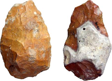
In The Welton le Wold handaxes & the earliest human activity in the Louth region (4 August 2014),  I had to look Louth up.  It's in Lincolnshire, an area that Caitlin has subjected to detailed study. The post discusses the latest dating evidence: "We therefore have, in the Welton handaxes, solid evidence that early humans were present in the Louth region around 400,000 years ago."
The Welton handaxes. Note the fine worked detail surviving after c400,000 years. 
The material in question comes from Welton le Wold quarry, which lies in the Lincolnshire Wolds around three miles to the west of Louth. They consist of three flint handaxes, a worked flake, and a number of fossil animal bones and teeth. Optically Stimulated Luminescence dating of the associated gravel suggests that the handaxes and fossil bones probably originated during a temperate period, the Hoxnian Interglacial, which lasted from around 424,000–374,000 years ago.

In her post, Caitlin discusses the life of the makers and their possible relationship to other English discoveries. In doing so, she outlines some of the huge climate and landscape changes that took place over the 400,000 years since and the way they might have affected both movement and evidence.

In Australia, we have become thinking in long terms as the date of human occupation of the continent has been progressively pushed back to now around 65,000 years. The time horizons in Europe and Africa are much longer because of the variety of Hominin species involved. One of the interesting questions is the possibility that we will find evidence of earlier hominin species in Australia. This seems more likely than it did a few years ago since the Hominin occupation of what is now Asia was far more widespread and complex than was once realised.

From Welton le Wold to the end of the last glacial period, c15,000 years ago 


This graph from Dr Caitlin Green provides a visual indication of temperature fluctuations over the last 800,000 years. Those fluctuations had huge impacts on human life.  
Caitlin continues the story in Of chalk and ice: the white cliffs of Louth in the Palaeolithic era  (24 September 2014). This traces the story from the handaxes probably used by pre- or ancestral Neanderthal hunters in the Hoxnian Interglacial around 400,000 years ago to the end of the last glacial period nearly 15,000 years ago.

The archaeological record is patchy, It appears that at 280,000 years ago there were at least occasional human visits, that around 57,000 years ago the as Neanderthal settlement and then around 35,000 years ago modern humans arrived.  The patterns reflect varying temperature patterns. The arrival of the Last Glacial Maximum effectively terminated much human settlement.

From 15,000 years ago

From 15,000 years ago, Caitlin's material is spread over multiple posts. I will list some of those posts in a moment, but I wanted to make some general comments first.

There is a constant battle between land and sea. The land extends itself through a process called progradation; rivers carry silt that can progressively build land through the formation of deltas. In New England, perhaps the most classic example is the lower Macleay valley where at the height of the Holocene the sea stretched inland to the site of modern Kempsey, only to be driven back to the current coastline through progradation.

For its part, the sea constantly erodes the land. Sometimes when there are big storms in combination with high tides, the sea can breach barriers reclaiming the land.

Sea level changes affect the whole process. Sea levels relative to land can change because sea levels rise. An extreme case is the rise in sea levels from 120 metres below current levels at the height of the Last Glacial Maximum to perhaps three metres above current levels at the peak of the warm Holocene period.

Sea levels relative to land can also change because the land itself rises or falls. Again, an extreme example is the shifts associated with the ending of the last ice age where the removal of the ice cap caused post glacial rebound. Land that had been forced down by the icecaps rose, causing land elsewhere to fall. Places that were ports, for example, find themselves inland. Places that were above water find themselves submerged. These are long term processes that continue today,

Post glacial changes are not the only factor at play, for continental shifts also affect land levels. Research suggests that as the Australian continent drifted north from Antarctica during the past 50 million years, it subsided by up to 300 metres and tilted to the north. Again, this is a long term process that continues today  It seems that the Australian continent is both moving north (1.5 metres in the last 22 years) and wriggling around as it moves.

One of the lessons all this, a lesson that Caitlin's posts with their focus on part of Lincolnshire illustrate, is that the local effects of these changes vary across the entire spectrum. You cannot simply apply generalised models without risk of error. You  actually have to analyse local conditions. This is true in general, but increases in importance as the time period under study increases.

Some of Caitlin's posts are: