One of the issues that has to be addressed in any regional history is just what boundaries to use. It is easy when you are writing a history based around a defined political entity, so much harder when you are dealing with a less defined entity whose boundaries have shifted with time.
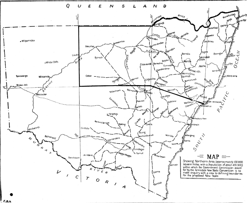
The following map shows the boundaries used by the 1924 Cohen New States Royal Commission. Comments follow the map. 
To begin with, this is the area on which the Cohen analysis was based. So analysis of the results of that Royal Commission has to take these boundaries into account. Then, too, the boundaries reflect opinion at the time.
Not that the boundaries bisect the Hunter Valley, leaving the Lower Hunter in NSW. This reflects perceptions that the lower Hunter would oppose self-government.
Now, as an historian, I have to include the Hunter in my history of New England. It just is. However, I have also to take into account changing perceptions of the boundaries and the way these have affected regional history.
It's an interesting challenge, especially when new state support is on the rise again, raising all the old issues.
Postscript
In a comments, Greg asked about the boundaries recommended by the Nicholas Commission. My proper map is in storage. However, the following graphic shows the back of a New England New State Movement envelope with the boundaries set out. The boundaries are mainly based on watersheds. The boundaries also encapsulate what has generally been known as the North, although New England new state support extended beyond these boundaries on the slopes and plains.


3 comments:
Jim, interesting that Bourke and Cobar are included in the Cohen boundaries, but Newcastle and Dubbo are not. Newcastle's exclusion would put some of what are now Newcastle's northern suburbs (Port Stephens) in the state of New England while the city and southern suburbs remained in NSW. Is there a map of the proposed boundaries from the Nicholas Royal Commission?
I suppose that when drawing boundaries they have to be somewhere and there is always a risk that communities will be divided. But Newcastle has a natural hinterland extending well into the Upper Hunter and the lower mid north coast from which it would be politically separated. It's southern hinterland is less extensive, probably petering out north of Wyong, given the greater gravity of Sydney and the growth of the Central Coast in it's own right.
Of course, if we end up with 15 to 25 states in the Commonwealth, as some have suggested, then it may be that New England and the Hunter could end up politically separate altogether.
My own view is that Newcastle has always seen itself as a significant part of Northern NSW. It is only in recent years that the idea of the Hunter or even Lower Hunter has become more prominent. It would be a shame to see a Northern NSW state emerge without Newcastle or a Hunter State without the north.
Hi Greg. Map added. The varying boundaries are interesting. I agree with you re the Hunter. It has always been part of the North.
Hi Jim, it is with great interest that I read your articles on the New England New State Movement, and fully expect that the continuing trend of Sydney orientated economic centralisation in NSW, that regional NSW, particularly the New England and Riverina districts, will again start to look seriously at forming new states.
I have a couple of questions on the boundaries issue on which I would value your opinion. Do you consider that boundary requirements for a New England State have altered since the Cohen Royal Commission, with a focus on the boundaries of local government areas included in the New England state rather than on the watershed of the catchment area? Also should a New England state be expanded to include the local government areas in the Macquarie River Basin as well as the Midwestern (Mudgee) shire council?
For my part, I am from Lake Macquarie and would love to see the whole Lake Macquarie catchment be included in a New England state. This would include the northern part of Wyong Shire which lies on the Lake Macquarie shoreline.
I understand that a "no" vote from Newcastle and the Lower Hunter did much to ruin New England's chance of statehood in the 1967 referendum, but circumstances have changed considerably in the lower hunter since that time. Issues such as the possibility of forced local government amalgamations from Sydney and the diversion of Hunter Valley generated income to pay for Sydney projects are matters which cause Hunter Valley residents to look to other statehood alternatives.
Post a Comment